West Midlands Key Health Data 2009/10
CHAPTER THREE: ACCESS TO HEALTH SERVICES IN BIRMINGHAM
Samuel Jones: West Midlands Cancer Intelligence Unit
Main Body
7: Changes in Heart Attack Admissions since the Smoking Ban
8: Measuring Disability Across the West Midlands
9: Surveillance of Clostridium Difficile in the West Midlands
ANALYSIS USING OPEN DATA
3.1 Introduction
This chapter builds on work from previous Key Health Data1 by looking at access to local health services in Birmingham. The aim is to identify and describe the number of people who are within a reasonable distance of their local health services, with the measure being ‘how long it takes to walk to the nearest GP surgery, pharmacy, dental practice or opticians’.
A road network is configured for the pedestrian user with average walk speeds. For the purpose of this piece of work, that of a woman with small child (2.592km/hr) is used2. Using GIS analysis, based on this speed, isochrones (areas of equal time) are generated for each health service. The isochrones can then be used to calculate and identify the number of people who live within a 5, 10, 20 or 30 minute walk, and those more than 30 minutes, from their nearest service.
With commitments, from both the Labour Government and the new Coalition Government, to free up public and Governmental data3, the emphasis on the analysis in this chapter will be upon the use of open data.
Data.gov.uk (see Chapter One) is a portal headed by Sir Tim Berners-Lee and Professor Shadbolt set up in early 2010 by the previous Labour Government. The portal is expected to grow under the new Coalition Government as part of its Big Society declaration3. Its overall aim is to open up Government datasets and to help drive forward innovation.
All health service locations used in this analysis have been derived from this portal. In addition to these locations the portal signposts LSOA population estimates (2008), LSOA population-weighted centroids, deprivation indices and boundary line data which are all used in this analysis.
OpenStreetMap (OSM), founded in 2004, is a form of Volunteered Geographical Information (VGI) with the aim of creating a free digital map of the world. The data is captured using GPS devices and entered onto a master database, created under a Creative Commons licence meaning it can be freely adapted, copied and shared. The source data is made available to download at no cost.
OSM has been chosen for this analysis since, not only is its a form of open data; it contains an array of footpaths and walkways which are not captured by current Ordnance Survey datasets making it more suitable for analysing pedestrian travel movement.
Furthermore, studies by Muki Haklay4 have shown that national completeness of OSM had grown to 70% by March 2010, with this figure being much higher in urban areas, and, in some parts, was even considered to be more complete than Meridian2.
Mapping of Birmingham, the City and its metropolitan area, was completed by OSM in December 20085.
Further analysis by the WMCIU has shown that, excluding motorways, OSM road data contained 3.4 million metres of road network within the Birmingham local authority area, compared with 3.1 million metres for ITN and 2 million metres for Meridian2 road networks.
3.2 Access to GP Surgeries
Including branch surgeries, there are 278 GP surgeries in Birminghams three PCTs.
Map 3.1: Access to GP surgeries generated by OSM
|
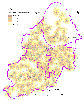
Across the whole Birmingham district, access to GP services appears to be very good with only 7% of the total population living more than a 30 minute walk from their nearest GP. Three quarters of the population are within a 20 minute walk.
For the most deprived group, access to GP services is slightly better; the above figure now halved leaving just 3% more than a 30 minute walk. 10% live within a 5 minute walk, whilst just over a third are within a 10 minute walk.
Table 3.1: Access to GP surgeries
|
|
|||||||||||||||||||||||||
At a PCT-level, Birmingham East & North was found to be the least well covered, with almost 10% of its population living more than a 30 minute walk to their nearest GP. Heart of Birmingham had the best accessibility with just 2% of its population more than a 30 minute walk away.
Figure 3.1: Access to GPs by PCT
|

3.3 Access to Pharmacies
There are 259 pharmacies within Birmingham, the most numerous of all the health services measured. Consequently, it was seen to be the most accessible of all the health services, with near complete coverage for the whole City.
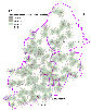
Map 3.2: Access to pharmacies generated by OSM
|

Just 4% of the Birmingham population were found to be living more than a 30 minute walk to their nearest pharmacy. Just over a quarter of the population were within 10 minute walk, and three quarters within 20 minutes.
Similar to GPs, the most deprived group were measured to have better access to pharmacies, with only 1.7% living more than 30 minutes away. For the most deprived group, however, they were less well represented by pharmacies than GP services for the shortest journey times (5 minutes and 10 minutes).
Table 3.2: Access to pharmacies
|
|
|||||||||||||||||||||||||
Of the PCTs, Heart of Birmingham Teaching has near-complete coverage with just 1% of its population more than 30 minutes walk from their nearest pharmacy. This figure was higher in the remaining to PCTs, with South Birmingham having the largest proportion more than 30 minutes away (6%).
Figure 3.2: Access to pharmacies by PCT
|

3.4 Access to Dental Practices
With 147 dental practices in Birmingham there are fewer services than GPs, and pharmacies. Subsequently, the travel time to this type of health service is slightly longer.
Map 3.3: Access to dental practices generated by OSM
|
Approximately 15% of the population live more than 30 minutes away from their nearest dental practice, with this figure almost identical for all people and the most deprived groups. Over half the population (57%) are located within a 20 minute walk.
Unlike the GP surgeries and pharmacies, the most deprived group were found to have the poorer access than the rest of the population, up to and including 20 minutes walk, although these differences were very small.
Table 3.3: Access to dental practices
|
|
|||||||||||||||||||||||||
Heart of Birmingham Teaching PCT was, again, found to have the best accessibility coverage with 7% of its population more than 30 minutes walk. Birmingham East & North was shown to have the poorest accessibility with a significant proportion – approximately a quarter – of its population living more than 30 minute walk to their nearest dental practice.
Figure 3.3: Access to dental practices by PCT
|

dental practices by PCT
3.5 Access to Opticians
With 137 opticians found in Birmingham, there were fewer opticians than any other health service investigated, and this subsequently resulted in greater travel times for the population of Birmingham.:
Map 3.4: Access to opticians generated by OSM
|

Over a quarter (28%) of Birmingham’s population live more than a 30 minute walk to their nearest opticians.
Similar to that of dental practices, the most deprived group were generally found to have the poorer access to services (the only exception being at the 10 minute break), with 30% of this group living more than 30 minutes walk away.
Table 3.4: Access to Opticians
|
|
|||||||||||||||||||||||||
Heart of Birmingham, once more, was found to have the best accessibility of the three PCTS with 15% of its population located more than 30 minutes away.
Birmingham East & North saw just over a quarter of its population living more than 30 minutes away, South Birmingham showing a significantly higher proportion with 42%.
Figure 3.4: Access to opticians by PCT
|

3.6 Summary and Conclusions
This analysis has shown that for the core local health services – GP surgeries and pharmacies – there is very good coverage in Birmingham with well over 90% of the population living within 30 minutes walk. The most deprived group were found to have greater proportions living within shorter journey times.
Dental practices, and in particular, opticians were found to be slightly less accessible with more significant proportions of populations living more than a 30 minute walk away. The most deprived group were also found to be less well served than that for GPs and pharmacies.
Heart of Birmingham, which also has very high levels of deprivation, however, was found to be the most accessible of Birmingham’s PCTs with much greater proportions of its populations residing closer to health services.
The analysis shows that open data can be a valuable resource in public health intelligence to help inform equity audits and needs assessments. The use of open data provides not only a low-cost option, but also has the advantage that it can be freely distributed and shared to a much wider audience, which has the potential to disseminate such information on the web.
The launch of OS OpenData (see Chapter One) has seen a range of geographical products made openly available, yet there is little guidance on the suitability of these products, or how they may compare with premium Ordnance Survey products, such as OS MasterMap ITN.
As part of OS OpenData, Meridian2 could have been used in this analysis. However an alternative open data source was selected in OpenStreetMap: with an extra million metres of road features, and a wide network of footpaths and walkways in the Birmingham area, it was deemed the most appropriate for this specific type of pedestrian-based analysis.
Figure 3.5 below, shows a summary of the analysis in this chapter by comparing both OSM and Ordnance Survey’s premium product, ITN:
Figure 3.5: Access to health services comparing OSM and ITN
|

Whilst some of these differences may be considered quite small, it is worth remembering that in a city the size Birmingham with a population of just over 1 million, a difference of 5% would equate to some 50,000 people.
Any differences, however, are far more evident at a more localised level. It is perhaps best outlined by the example below, where in OS ITN the lack of a simple footbridge across a canal cuts off an adjacent neighbourhood from its closest GP surgery:
Figure 3.6: Differences between OSM and ITN isochrones
|

Although ITN is considered Ordnance Survey’s most accurate and detailed road dataset, and has almost the same metres of road network as OSM in Birmingham, it lacks important footpaths and walkways which will impact upon pedestrian-based accessibility analyses.
A new component of ITN, the ITN Urban Paths Network, is due be released in the next few months and may go some way to addressing some of these issues.
The OpenStreetMap project, however, with its global team of dedicated volunteers continually mapping and updating the OSM database looks set to grow further, and provides a data-rich mapping source at no cost.
References and Acknowledgements:
- Key Health Data 2004/05 Chapter 6: Access to Services, Dr Richard Wilson
- DfT Road Research Laboratory 1965 ‘Research on Road Traffic’
- Building the Big Society’, Cabinet Office News Release and announcement, 18th May 2010
- Based on Haklay, Mordechi (Muki), March 2010, OpenStreetMap Completeness for England for March 2010 http://wiki.openstreetmap.org/wiki/Birmingham
Map data (c) OpenStreetMap (http://www.openstreetmap.org/) and contributors, CC-BY-SA (http://creativecommons.org/licenses/by-sa/2.0/).
Aerial imagery supplied by ESRI. Source: GetMapping. Licensed under a Creative Commons Attribution-Non-commercial share-alike license (http://creativecommons.org/licenses/by-nc-sa/3.0/us/)
Ordnance Survey material ITN MasterMap product, Copyright 2010. All rights reserved.
(O.S. Licence No: 100020290). Prepared by West Midlands Cancer Intelligence Unit (2010) on behalf of Department of Health.
Meridian2 (OS OpenData) contains Ordnance Survey data © Crown copyright and database right 2010.
For more information please contact Sarafina
Cotterill
© Public Health, Epidemiology and Biostatistics Unit, School of Health and Population Sciences, University of Birmingham